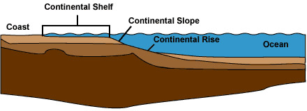
A continental shelf is a submerged, gently-sloping ledge that surrounds the edge of a continent. On the landward side it is bordered by the coastal plain and on the seaward side by the shelf break, where the continental shelf gives way to the steeper continental slope.
The coastal plain, continental shelf and continental slope together comprise what is called the continental terrace. Farther out to sea beyond the continental slope is the continental rise and then the abyssal plain - the sea floor of the deep ocean.
Knowledge of the continental shelf has increased greatly during the 1950s and beyond, helped by geophysical techniques originally developed to prospect for offshore oil and gas reserves. Particularly valuable have been the various sonar mapping methods, which use ultrasonic sound to penetrate the seawater.
The depth of the seabed can be measured using echo-sounders, and lateral sonar beams can be used to obtain pictorial views of the seabed that are similar to aerial photographs of the land.
Continental Shelf Dimensions
The continental shelf constitutes 7 to 8 percent of the total area of the sea floor, forming the bottom of most of the world's shallow seas.
The width of the shelf varies from place to place; off the coast of southern California in the United States, for example, the shelf is less than 1km wide, whereas off South America, between Argentina and the Falkland Islands, it is more than 500km wide.
It is narrowest on active crustal-plate margins bordering young mountain ranges, such as those around the Pacific Ocean and Mediterranean Sea, and broadest on passive margins -around the Atlantic Ocean, for example.
The shelf slopes gradually (at an average of only 0.1° to the horizontal) down to the shelf break, the mean depth of which is 130m below sea level.
The continental slope, the other main part of the continental terrace, begins at the shelf break and extends to a depth of between 1.5 and 3.5km. The slope varies from 20 to 100km wide and is much steeper than the shelf, having an average inclination of 4°, although in some places it is as steep as 20°.
Factors Affecting Continental Shelf Dynamics
 The continental shelf is affected by two main factors: earth movements and sea-level changes.
On passive crustal-plate margins the shelf subsides as the Earth's crust gradually cools after rifting and becomes thinner through stretching. These processes are often accompanied by infilling with sediments, the weight of which adds to the subsidence of the shelf.
In Polar Regions the weight of ice depresses the continents by a considerable amount, with the result that the shelf break may be more than 600m below sea level.
Superimposed on the results of subsidence is the effect of worldwide changes in sea level which, during the Earth's history, have repeatedly led to drowning of the continental margins.
During the last few million years sea-level changes were caused mainly by the freezing of the seas in the Ice Ages. The last major change, the melting of ice at the end of the Pleistocene Ice Age several thousand years ago, released water into the oceans and submerged the shelf. Since then shorelines have remained comparatively unchanged.
Many of the earlier changes in sea level, however, were related to the Earth's activity. During quiescent phases, when the Earth's surface is being eroded and the resultant debris deposited in the seas, the sea level rises as water is displaced by the accumulating debris. During active mountain-building phases, on the other hand, the sea level falls.
Changes in the rate at which the continents move apart also cause fluctuations in sea level. During times of rapid separation, the rocks near the centers of spreading of the ocean floor (from where the continental movements originate) become hot and expand, thereby displacing seawater, which drowns the edges of the continents.
Continental Shelf Topography
The continental shelf has a varied relief. Drowned river valleys, cliffs and beaches - submerged by the recent (in geological terms) sea-level rise - are common, and in northern latitudes the characteristic features left by retreating ice sheets and glaciers (U-shaped valleys and moraines, for example) are apparent.
Furthermore the shelf is not unchanging even today. It is being altered by numerous influences that affect the sediments left behind by the sea-level rise at the end of the Pleistocene Ice Age.
In strongly tidal areas, such as the Yellow Sea and the North Sea, currents sweep sand deposits into wave-like patterns that resemble the wind-blown dunes in deserts. If, however, a large amount of mud is flowing onto the shelf from a river mouth, the mud may completely obscure the underlying features.
In addition to physical processes, the shelf is also affected by biological activity, notably by the growth of coral reefs in tropical areas.
Continental Slope Topography
The continental slope is cut by numerous submarine canyons, many of which are as large as the largest canyons that occur on land. Their gullied sides resemble the rugged "badlands" in the USA.
Much of the sediment carried off the continental shelf by wave action passes down the submarine canyons (although some is also distributed along the continental slope) and the deeper parts of the canyons show the effects of turbidity currents -dense mixtures of sediment and water which, often started by a submarine landslide, flow rapidly down the canyons. These turbidity currents may reach speeds of 40km/h and travel more than 80km before coming to rest.