While some parts of a coast are being eroded by constant pounding of waves, the material removed is being carried by the sea to other areas where it is deposited, forming any of various characteristic shoreline features, such as beaches and spits.
There are two main mechanisms by which eroded material is transported along coastlines: longshore drift, in which the debris is carried along by currents moving parallel to the shore, and beach drifting, in which the debris is moved by the action of waves on the shoreline itself.
Beach drifting usually occurs where waves strike the shore obliquely. The uprush (swash) carries material diagonally up the beach, and the back wash drags the loose fragments back down at right-angles to the shoreline. As this process continues, the coastal material (sand and pebbles, for example) is gradually moved along.
Beaches
A beach is an accumulation of (usually) sand and shingle lying in the littoral zone (the region of a shore between the high and low water levels).
On hilly coasts small bay-head beaches develop where debris is trapped between rocky headlands; many of the coves of south-western Britain and northwestern France are of this type.
In contrast, on low-relief coasts there is often a large expanse of sand with a narrow shingle beach ridge on the landward side. At low tide the sands of gradually sloping beaches may extend seawards for several kilometers - as occurs in the bay of St Michel on the northern coast of France, where the sandy beach extends for about 15km at low tide.
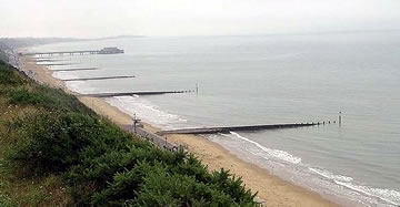
 Beaches are an important economic asset to coastal resorts, many of which have groynes/groins that protect their beaches from removal by drifting. Sand and pebbles accumulate on the side of the groynes facing the direction of drift, whereas on the other side of the groynes material is washed away but is trapped by the next groyne.
Spits and Bars
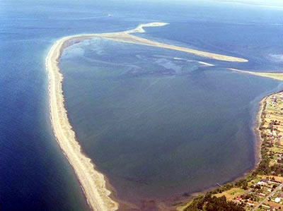
Where both beach drifting and longshore currents occur along an irregular coastline, spits and bars of sand may form. Where the coast turns inwards into a bay or estuary, eroded material is usually carried past the inlet and deposited in the deeper water beyond. As this process continues a ridge or embankment is gradually built out from the coast, forming a spit. The spit terminates in open water at a point where cross currents prevent further forward growth.
 Spits - particularly long ones - usually curve towards the shore, an effect caused by the tendency of oblique waves to be refracted (that is, to swing around the end of spits) or by the approach of waves from a different direction. There are many of these hooked (recurved) spits along the eastern seaboard of the United States where southward-flowing currents carry eroded material across river mouths.
If a spit continues to lengthen unimpeded, it may eventually form a bay bar (or barrier beach) linking two headlands. Lagoons and marshes often develop behind such bay bars. Several curved bay bars occur around Danzig (Gdansk) in Poland; they are composed mainly of sand and are known locally as nehrungen.
A bar that extends from the mainland to an island or from one island to another is called a tombolo. The name originates from the Italian example near Orbetello (about 130km north-west of Rome), where two bars of shingle (which enclose a lagoon) link the mainland to a rocky island. Another good example is Chesil Beach in Dorset, England, which is a 24km-long shingle ridge that begins at Bridport and, after running along the coast, links the Isle of Portland to the mainland.
Where there is a wide zone of shallow water, offshore bars may form several kilometers from the coast. Running parallel to the shoreline, usually discontinuous, these bars are also sometimes known as barrier islands. These are relatively common along the eastern seaboard of the USA - along the coast of North Carolina, for example, where a series of barrier islands extends more than 150km north and south of Cape Hatteras.
Cuspate Forelands
Triangular outgrowths consisting mainly of shingle ridges are called cuspate forelands, thought to result from either the convergence of two spits or the combined effects of waves from different directions. Cape Canaveral in Florida in the United States, for instance, was formed as a result of deposition by opposing longshore currents set up by eddies from the Gulf Stream. Another example is the Darss peninsula in Germany, where the sediment has advanced about 430m seawards in the past 200 years and enclosed several shallow brackish lagoons (known locally as bodden).
Coastal Sand Dunes
Many beaches are backed by sand dunes, formed as coastal winds blow sand from the beaches farther inland. On the Baltic coast the inland migration of dunes has been measured at the rate of 6m per year, some of the dunes rise to more than 60m and threaten to encroach on agricultural land.
A larger dune belt occurs in the Landes region of western France, where the dunes extend southwards along the coast from the Gironde estuary to Biarritz.
To prevent sand dunes from moving inland, pine trees and marram grasses have been planted in many dunes. Brushwood fences can also control sand drift.
In some areas lagoons and marshes behind the dunes help to prevent the inland migration of sand.