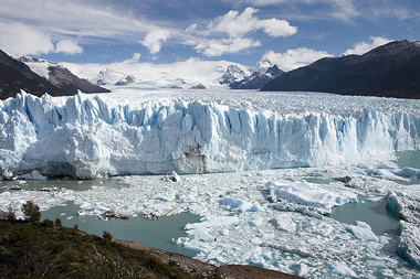
A glacier is a thick mass of ice that grows as snow accumulates, compacts and recrystallizes. Glaciers take hundreds of thousands of years to form.
Glaciers are involved in the water cycle, or hydrologic cycle. Often during the water cycle, rain, snow, hail or sleet that falls on the ground runs into rivers and streams, eventually making its way to lakes, seas and oceans. However, at high altitudes or high latitudes, precipitation may become part of a glacier instead. Water that fell from the atmosphere can be stored in a glacier for thousands of years.
Although glaciers appear completely still, they move slowly, and act as agents of erosion, moving large amounts of sediment from place to place. Thus, they play an important role in the rock cycle.
 Quick Glacier Facts
1. Glaciers cover about 10% of the Earth.
2. Glaciers hold 75% of the world's fresh water.
3. In the state of Washington alone, melting glaciers provide 1.7 trillion gallons of water each summer.
4. Glaciers appear blue because ice absorbs all other colors but reflects blue.
5. If all the Earth's glaciers melted, sea levels would rise 230 feet (70 meters)
Types of Glaciers
There are many different types of glaciers. Some of these are valley glaciers, piedmont glaciers, ice sheets and ice caps.
Valley Glaciers
Valley glaciers are formed in high mountains. Also known as alpine glaciers, they follow valleys where streams once flowed. They tend to be long and narrow, with high rocks on either side. Like rivers, they can break up into tributaries as they move downstream.
The largest valley glacier in the world is Aletsch Glacier. It is 14 miles (23 kilometers) long with a total area of 45 square miles (125 square kilometers.)
Piedmont Glaciers
Piedmont glaciers are found at the bases of steep mountains. They form when valley glaciers reach the bottom of a mountain and then spread out, forming a wide sheet of ice. A piedmont glacier can contain ice from just one valley glacier, or it can be made up of ice from many glaciers on the same mountain, which coalesces to form a single sheet.
One of the largest piedmont glaciers is Malaspina Glacier, along Alaska's southern coast. Located at the base of the St. Elias Mountains, it covers an area of more than 2,000 square miles (5,000 square kilometers).
Ice Sheets
Ice sheets are enormous glaciers that flow outward in all directions, completely covering all but the highest areas of land. Today, there are only two ice sheets on Earth: the Greenland Ice Sheet and the Antarctic Ice Sheet, which together cover almost one tenth of the Earth's land.
The Greenland Ice Sheet covers 0.7 million square miles (1.7 million square kilometers), about 80 percent of Greenland itself. It's almost 1.6 miles (2.3 kilometers) thick on average, and more than 10,000 feet (3,000 meters) high in some place.
With an area of almost 5.4 million square miles (13.9 million square kilometers), the Antarctic Ice Sheet covers almost the entire continent of Antarctica. This enormous ice sheet contains 80 percent of the ice on Earth and almost two thirds of our planet's fresh water.
When ice from the Antarctic ice sheet flows into the ocean, it creates ice shelves, flat masses of floating ice that are still attached to land on at least once side. The Antarctic ice shelves encompass an area of about 0.6 million square miles (0.6 million square kilometers).
Ice Caps
Ice caps are much smaller than ice sheets. However, they also obscure the underlying landscape completely. There are ice caps in Iceland and on several islands in the Arctic Ocean.
Glaciers in the Past
Throughout the history of the Earth, glaciers have advanced and retreated repeatedly. There have been many glaciation events. The earliest that we know of occurred over 2 billion years ago, when the Earth was believed to be covered with ice. Other glaciation periods include the Cryogenian period, which occurred from 850 to 630 million years ago (mya), the Andean-Saharan Glaciation, 460 to 430 mya, and the Karoo Ice Age, 360 to 260 mya.
For most of the Earth's history, there have been no glaciers at the poles. While the Antarctic Ice Sheet is about 20 million years old, the glaciers in the Arctic are only about 3 million years old. From about 2.6 mya to the present day, a time know as the Quaternary Glaciation (Ice Age) glaciers have spread out over the Earth and retreated again and again Right now, we are living in an interglacial period that began about 12,000 years ago, after glaciers retreated.
Glacial Landforms
As glaciers move, they erode the landscape, creating many different types of recognizable landforms. The movement of glaciers over millions of years has completely transformed the surface of the Earth.
When a glacier moves, it erodes the rocks beneath it in two ways, by abrasion and by plucking
Abrasion occurs when rock debris freezes onto the bottom of the glacier. It rubs against the bedrock below, acting like sandpaper. Plucking takes place when glacial ice freezes onto rock projections; the glacier tearing out blocks of rock as it moves.
Glacial Valleys
When a glacier passes through an old river valley, it erodes the valley. The valley becomes straighter, wider and deeper, its shape changing from a narrow V to a wider U. This wide, U-shaped valley is known as a glacial trough.
As the valley deepens, tributary streams remain high above it. When these tributaries retreat, they leave behind hanging valleys. Waterfalls often plunge down the sides of hanging valleys. Such waterfalls can be found in Lauterbrunnen Valley in the Alps and in Yosemite National Park in California.
Where several tributary glaciers converge in a glacial trough, the increased gouging by the extra ice causes a steep step in the trough, known as a trough end, to form.
The floor of a glaciated valley is often eroded very unevenly. Long, narrow ribbon lakes may form where there are elongated depressions.
If a glacial trough extends down to the coast, it can form a long, steep-sided inlet, known as a fjord.
Cirques
Cirques, known as corries in Scotland and cwms (pronounced cooms) in Wales, are large hollows found around mountain peaks. They are created where the glacier first forms, at the spot where snow. Cirques grow as frost shatters their walls and ice plucks away rocks along the sides of the glacier.
The Aletsch Glacier is fed by several tributary glaciers, each emerging from a cirque.
When glacial erosion causes the walls of two adjoining cirques to meet, knife-edged ridges, known as arêtes, form. When several cirques form around a mountain, they form spires known as horns. When the cirques grow larger and converge, the horns join to create one isolated horn. The Matterhorn is such a horn.
A tarn is a lake that forms in a mountain when the ice in a cirque melts.
Moraines
A moraine is a layer of debris left by a glacier. A terminal moraine forms at the end of a glacier's path, where the ice melts at the same rate as the glacier is growing. Although the glacier itself has stopped moving, ice on the glacier continues to flow forward, carrying sediment to the front. As the ice melts, the terminal moraine continues to grow.
Terminal moraines can be found in many part of the American Northeast and Midwest. Long Island in New York and the Kettle Moraine in Wisconsin are both terminal moraines.
A recessional moraine is created when a glacier stops moving temporarily, during a time of glacial retreat. Recessional moraines are higher than terminal moraines.
When a glacier starts melting faster than it grows, a ground moraine begins to form. The front of the ice retreats, meltwater continues to deposit sediment. Eventually, a gently rolling plain of debris is created.
Lateral moraines are ridges that form when a glacier picks up large amounts of debris from the walls of a valley and then melts, leaving the debris behind.
A medial moraine forms when two valley glaciers join to from a single stream of ice. The debris that was carried by the two glaciers joins and forms a dark stripe of debris down the middle of the new, larger glacier. After the glacier melts, a ridge appears in the middle of the valley.
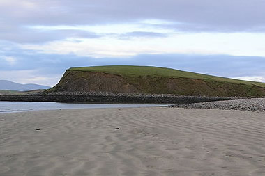 Drumlins
Drumlins are asymmetrical hills, ranging from 50 to 200 feet (15 to 60 meters) high. They are found near other glacial landforms. A drumlin has a steep slope on one side and a gentler slope on the other.
Drumlins are never found alone. They form large clusters known as drumlin fields. A drumlin field east of Rochester New York has about 10,000 drumlins. In Strangford Lough in County Down, Ireland, drumlins form islands within the lough itself.
It's believed that drumlins form when glaciers advance over ground moraine that was left behind previously.
Eskers
Eskers are long, sinuous ridges of gravel and sand found winding along glaciated lowlands. They formed when streams flowed in tunnels beneath the ice and then deposited debris at the mouths of the tunnels. Eskers are common in Finland and Sweden, where they run across the country between lakes and marshes.
Kames
Kames are mounds of sand and gravel. They form when the meltwater deposits sediment into depressions at the wasting end of the glacier. When the glacier melts, these mounds are left behind.
Kettle Holes
Kettle holes are water-filled depressions. They form when a receding glacier leaves patches of ice behind. Kettle holes remain after this stranded ice melts.
To learn more about glaciers, please visit the National Snow and Ice Data Center.