Although the ground beneath our feet usually seems stable, the continents we stand on are moving all the time. The theory of plate tectonics explains the how the continents move on the Earth’s surface. It tells us why some mountain ranges form, why earthquakes tend to occur at particular places on Earth and why fossils have been found in unusual places.
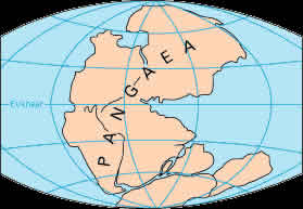
As far back as the late 16th century, some people noticed that the eastern coast of South America and the western coast of Africa seemed to fit together like pieces of a jigsaw puzzle. Alfred Wegener, a German geophysicist, proposed the hypothesis of Continental Drift in the early 20th century. Wegener said that all of the continents were once joined together in a supercontinent, known as Pangaea, and had drifted apart. He noticed that fossils of plants and animals that could not have crossed oceans on their own had been found distributed throughout the different continents of the southern hemisphere. For example, archeologists had discovered Mesosaurus fossils in both Africa and South America.
At first, the scientific community did not accept the idea of continental drift because there was no way to explain how the continents moved. It was not until the latter half of the 20th century, when geologists were able to measure seismic activity and the orientation of magnetic fields in rocks in relation to the Earth’s magnetic poles, that the concept of continental drift was accepted.
The theory of plate tectonics says that the lithosphere, which consists of the Earth’s crust and the upper part of the mantle, is divided into many small plates. Some of the larger plates contain a whole continent plus part of the ocean floor.
Lithospheric plates, or tectonic plates, move constantly, at a rate of about 2 inches (5 centimeters) a year in response to unequal heat distribution within the Earth. Now, Europe and North America are moving away from each other, and Africa is moving toward Europe at this rate.
Sometimes two plates bump together. If a plate is covered with dense oceanic crust, it can sink beneath the other plate and descend into the mantel.
Plates covered in continental crust are too buoyant to sink. When two plates topped with continental crust meet, they collide and form a mountain belt. The Himalayas formed during such a collision.
Earthquakes tend to occur at plate boundaries.
The place where two plates come together is known as a convergent boundary. Plates pull away from each other at divergent boundaries. When plates separate at mid-ocean ridges; they create fractures that fill up with molten rock from the mantle. When this rock cools and solidifies, it causes the ocean floor to spread, a phenomenon known as seafloor spreading. Sediments near ocean ridges are younger and thinner than sediments further away from mid-ocean ridges, proof that rocks near mid-ocean ridges formed recently.
Places where plates slide against each other are transform fault boundaries. California’s San Andreas Fault, known for its earthquakes, is an example of such a boundary.