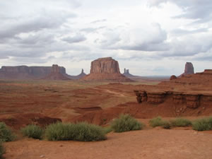
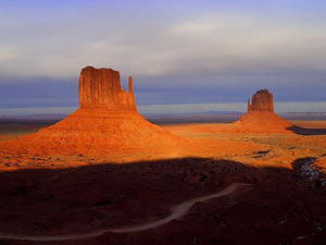
Monument Valley, on the Utah-Arizona border, is famous for its many "monuments" - remnants of erosion that resemble structures created by human beings because they are higher than they are broad.
Many of the monuments in the valley reach heights of up to 300m (1,000 ft).
 The colorful names of the monuments have been inspired by their interesting shapes. Castle Rock appears to be surrounded by battlements. Hen-in-a-nest resembles a squatting fowl. The Mittens are two gigantic formations that stand close together. Each has a narrow column of rock - the "thumb", next to a broad butte of rock, the "fingers".
Formation of Monument Valley
 More than 200 million years ago, the area that Monument Valley now occupies on the Utah-Arizona border was a windswept desert of red sand.
The land became flooded by a sea, and heavy deposits of mud fell as sediment to the seabed and compressed the sand into red sandstone. The thick layers of mud became shale.
Around 65 million years ago, the area was uplifted. The seabed became a huge, flat plateau of sandstone covered by a thin layer of shale and conglomerate, a type of hard, sedimentary gravel.
Erosion began to occur. The movement of the earth had opened up cracks and fissures in the shale, and water and wind etched their way in to the underlying sandstone and bore it away.
Clefts in the rock were deepened and broadened until they formed a labyrinth of canyons and gullies.
As a result, sandstone terraces were whittled down into rocky tablelands or mesas that were then reduced to monuments.
These monuments consist of a vertical shaft of red sandstone topped by a cap of more resistant rock that has protected the lower layers from erosion.
Often the monuments are surrounded by a spreading cone of sandstone debris that has fallen from the existing structure.
This is a sign that erosion is still in progress, and in several thousand years, these final remnants of the sandstone plateau will be completely flattened.