Asia is the largest continent on Earth, in area as well as in population.
Here are just some of Asia's incredible sites.
Himalayas
The Himalayas are the Earth's highest mountain range as measured from sea level. They lie on the border between Nepal and Tibet.
The Himalayas form a shallow crescent that ranges from 160km (100mi) to 240km (150mi) wide, and is around 2,415km (1,500mi) long, roughly the distance from London to Moscow.
Three of the world's largest rivers - the Indus to the north and west, the Brahmaputra to the north and east, and the Ganges to the south - encircle the Himalayas almost completely.
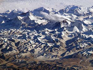 The Himalayas are actually composed of three separate mountain ranges. The lowest and southernmost range, known as the Siwalik Hills, has peaks reaching around 1,500m (5,000ft) above sea level. Farther north are the Lesser Himalayas, around three times as high. Both ranges are patterned with fertile valleys where the climate is mild and many villages thrive.
The northernmost range, the Greater Himalayas, contains Mount Everest, the world's highest mountain. Mount Everest is 8,848m (29,028ft) above sea level.
The name "Himalayas" comes from the Sanskrit word for "abode of snow" - a reference to the mountains' snowcapped peaks.
Formation of the Himalayas
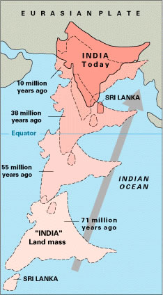 The Himalayas began their existence on the sea floor. Fossil fish and the remains of other marine life can be found amidst the snow on these high mountains.
The oceans and continents of the world are carried on large sections of rock known as "tectonic plates". Around 60 million years ago, the tectonic plate that carries India moved northward, crushing the floor of an ocean known as the Tethys against the land of Asia. The rocks between them buckled and broke. The ocean floor folded and cracked. Layer of disturbed rock piled on top of each other.
Century by century, the uplifted land became mountains and plateaus, and the Himalayas came to be the magnificent range that we know today.
These irresistible forces are still at work. Geologists estimates that the Himalayas are increasing in height at a rate of about 5cm (2in) a year.
Mount Fuji
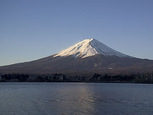
Mount Fuji, a dormant volcano, is the highest mountain in Japan.
Fuji is 3,776m (12,388ft) high.
From its crater, which measures almost 700m (2,297ft) across, it slopes down at an angle of 45 degrees and gradually levels out before reaching the plain.
Its base, 40km (25mi) in diameter and 125km (78mi) in circumference, is almost perfectly circular.
For most of the year, the peak of the mountain is covered in snow, while its lower slopes are covered in lush vegetation or moorland.
Mount Fuji's perfect symmetry has long been considered the ultimate Japanese symbol of beauty.
 Eruptions
Mount Fuji first erupted around 300,000 years ago from below a wide plain. Fuji's present shape is the result of outpourings from several cones, which built up alternate layers of solidified lava and a conglomerate composed of cinder, ash and lava.
These layers represent the sequence in which the volcano, which geologists call a stratovolcano, erupts: huge volumes of molten lava spread out evenly over the mountain slopes. Violent explosions follow, in which dense clouds of cinder, ash and lava pellets are ejected high into the air.
Buddhist teachings say that Fuji was created when a massive earthquake struck the land late one night in 286 BC. The same seismic upheavals opened up the earth and formed Lake Biwa, Japan's largest freshwater lake, 280km (175mi) to the west.
The first recorded eruption of Mount Fuji took place in AD 800. Since then, it has erupted ten more times. Outpourings from each eruption, the outpourings concealed the remnants of two ancient craters, known as Old Fuji and Komitake.
Fuji's last eruption took place in 1707. Clouds of ash and cinder were carried as far as Tokyo, 100km (62mi) to the east. Streets in Tokyo were blocked and some of the city's buildings were damaged.
Angkor Wat
Angkor Wat is a 203 acre (820,000 square meter) temple complex in Cambodia. King Suryavarman II of the Khmer Empire commissioned its construction at the beginning of the 12th century. It is thought that he wanted it to be his final resting place.
There is a picture of Angkor Wat on the Cambodian flag.
When it was built, Angkor Wat was dedicated to Vishnu, a Hindu God.
However, the Khmer Empire converted to Buddhism in the late 13th century, and images of Buddha, as well as other objects associated with Buddhism, have been added.
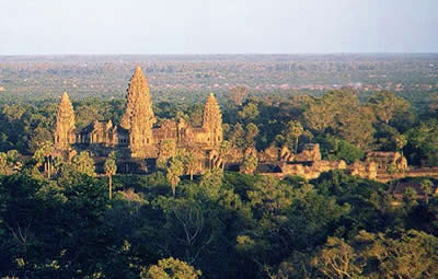 The temple is made up of rectangular structures nested inside one another. The innermost one has four towers in the shape of lotus buds in the corners and a fifth tower in the center.
More than 200 feet (60 meters) high, the temple is supposed to represent Mount Meru, a sacred mountain in Hindu mythology.
Images of guardian spirits decorate the walls of the temple. There are bas reliefs of scenes from Hindu mythology and literature.
The temple at is made of sandstone blocks that are placed so perfectly that it is difficult to see where they are joined together. This style of construction has become known as Angkor Wat style.
A 15 foot high (4.5 meter) wall surrounds the temple complex. The wall's entranceways, which have towers known as gopuras, are cover with bas reliefs and carvings.
Angkor Wat is thought to have been used for astronomical purposes. During the spring equinox, the sun rises directly over the central tower.
A moat surrounds Angkor Wat. This moat is thought to symbolize the cosmic ocean.
Angkor Wat is a UNESCO World Heritage Site.
Akashi-Kaikyo Bridge
Akashi-Kaikyo Bridge in Japan is the longest suspension bridge on Earth. It connects the city of Kobe, on Japan's main island of Honshu, with Awaji Island. The two islands are separated by Akashi Strait.
The central span of Akashi-Kaikyo Bridge, which is also called Pearl Bridge, is 6,532 feet (1,991 meters). Its towers are 978 feet (298 meters) high.
Construction of the bridge began in 1988.
Building the bridge was a dangerous feat. Akashi Strait is a treacherous stretch of water, known for its high winds and fierce storms.
In 1955, two ferries sank in the strait and many people, including 168 children, were killed.
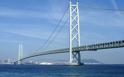 The idea of building a bridge between the two islands was advanced after the tragedy.
The region is also earthquake prone. In fact, an earthquake struck the area in 1995, while the bridge was still being constructed. The earthquake moved the towers so far apart that when the bridge was completed 1998, 10 years after construction began, it was about 3 feet (1 meter) longer than it was originally designed to be.
In order for the bridge to withstand the violent winds, typhoons and earthquakes that occur in the area, new materials had to be constructed and new engineering systems had to be designed.
A new form of reinforced concrete was used in the foundations.
36,380 wires were used in each suspension cable.
A new girder-stiffening system was developed to cope with high wind speeds. The largest wind tunnel in the world was constructed to test the bridge's performance in high winds.
Tuned mass dampers were built into the towers to help reduce vibrations during earthquakes. The bridge can safely expand up to 6 ½ feet (2 meters) a day.
Akashi-Kaikyo Bridge is a marvel of modern engineering. It can withstand wind gusts of up to 178 miles per hours (286 kilometers per hour) and an 8.5 magnitude earthquake with an epicenter just 90 miles (150 kilometers) away.
Banau Rice Terraces
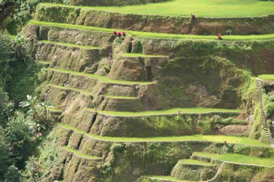
The Banaue Rice Terraces are a group of agricultural terraces on the island of Luzon in the Philippines. They were built between 2,000 and 3,000 years ago. Farmers still grow rice and vegetables on them today.
These terraces, which have stone or mud walls, were carved into the Philippine Cordillera Mountains of the island's Ifugao region by farmers using primitive tools. There are hundreds of terraces, covering an area of 4,000 square miles (10,360 square kilometers) and reaching a height of 4,920 feet (1,500 meters). If placed end to end, they would reach halfway around the world.
The farmers who built these terraces thousands of years ago also built an elaborate irrigation system for them.
 Some of the original builders may have belonged to the Miao tribe of China, who were exiled to the Philippines after they rebelled against China's Emperor You the Great. When In China, the Miao lived in the mountains and grew rice. After arriving in the Philippines, the Miao may have assimilated with the indigenous people of Ifugao and taught them their agricultural methods.
Knowledge of how to maintain the Banaue Rice Terraces has been passed on orally for at least 2,000 years.
Rice is the main crop in the region, and the Ifugao people have many festivals associated with the planting and harvesting of rice.
The Banaue Rice Terraces are a UNESCO World Heritage Site.
Ayutthaya
Ayutthaya was once the capital of Siam, now Thailand.
The ancient city of Ayutthaya is located on an island at the confluence of the Chaophraya, Pasak and Lopburi rivers, 50 miles (80 kilometers) north of Bangkok.
Ayutthaya, which was founded around 1350 AD, was once a center for world trade. The population of Ayutthaya, which included merchants from all over Asia and Europe, exceeded one million during the city's peak in the 17th and 18th centuries.
At the center of the city was the King's Grand Palace.
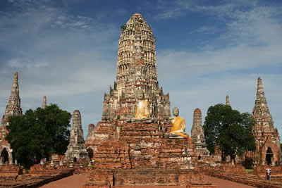 Huge temples and monasteries surrounded the palace.
The city was planned carefully, with roads, canals and moats built around important structures.
Water was managed using a hydraulic system.
Buildings in Ayutthaya, which were encrusted with gold leaf, displayed two distinct architectural styles. Older buildings had tall spires, known as prangs, which resemble fingers. Newer buildings are covered with bell-shaped structures known as chedis. A chedi is a type of stupa, a Buddhist monument that holds sacred relics.
As Ayutthaya grew and prospered, the kings of Ayutthaya conquered the city-states and kingdoms that surrounded it.
In 1767, the Burmese invaded Ayutthaya and burned most of the city to the ground.
The city was never rebuilt.
Today, Ayutthaya is an important archeological site.
Three chedis, which hold the remains of three kings, characterize the ruined temple of Wat Phra Si Sanphet.
Buddha statues in the temple of Wat Chai Watthanaram had their heads chopped off by the invading Burmese.
Another famous temple is the temple of Wat Mahathat.
A large bronze Buddha, which was once at the Grand Palace, can now be seen at the temple of Viharn Phra Monkgol Bopit.
Much of what we know about Ayutthaya in its prime comes from maps drawn by 18th century European merchants.
Ayutthaya is a UNESCO World Heritage Site.
Band-e Amir Lakes
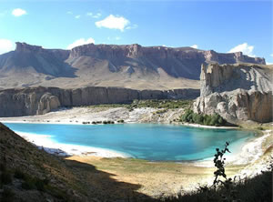
The Band-e Amir Lakes lie among the foothills of the Hindu Kush, the second highest mountain range in the world.
Of the six lakes, Band-e Panir is the smallest, with a diameter of approximately 100m (330ft). The largest is Band-e Zulfiqar, which measures some 6.5km (4mi) in length.
The deep blue color of the lakes is due to the clarity of the air as well as the purity of the water.
 The Band-e Amir River draws its water from the spring melt-water in the surrounding mountains. This gentle outflow of water seeps into the ground and percolates slowly through the underlying limestone, dissolving its principal mineral, calcium carbonate.
Dripping water collects to form underground pools and streams in the caves and passages left behind by the dissolved rock. As they emerge from the hills, the streams become the headwaters of the river.
Laden with dissolved calcium carbonate and other minerals, the river tumbles into a narrow, twisting valley, no more than 12km (7mi) in length.
Each lake is dammed by a long ridge of rock and lies at a different level to its neighbors, thus allowing the river to flow from one to the next.
Dams of Travertine
Aquatic plants grow in the patches of swamp that are created by the streams slowly meandering between the lakes. These plants release a chemical that reacts with the calcium carbonate dissolved in the water and forces it out of solution.
Under the intense heat of the sun, the mineral hardens into a pale waxy substance known as travertine.
Over many centuries, travertine deposited around the margins of the lakes, have created dams that trap water in increasingly large basins. These dams are usually about 10m (33ft) high and 3m (10ft) thick.
As water from the highest lake becomes filled with river water, the water trickles over the lake's travertine dam and then flows toward the next highest lake, and the deposition process continues.
The Hindu Kush
The Hindu Kush extends 800km (500mi) from northeast Afghanistan to northern Pakistan where its tallest peak, Tirich Mir, is 7,692m (25,236ft) in height. Only the Himalayas are taller.
The peaks around the Band-e Amir Lakes rise to around 3,000m (10,000ft) in height.